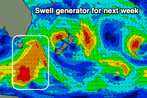
Small run of southerly swell
Eastern Tasmania Surf Forecast by Craig Brokensha (issued Friday 3rd July)
Best Days: Sunday and Monday south swell magnets, Tuesday morning, Wednesday, Thursday south swell magnets
Recap
A small though wind affected 1-2ft of N/NE windswell yesterday, tiny today.
This weekend and next week (Jul 4 - 10)
We've got a bit of S'ly swell on the way for the weekend and better quality energy through next week our southerly swell window becomes more active.
Over the weekend a couple of relatively weak but strengthening fronts will push up and past us, generating some short-range S'ly swell.
The first this evening won't have any real favourable alignment or strength, so tomorrow looks mostly flat.
Into the afternoon though a stronger front will project strong S/SW winds up past us, weakening a touch Sunday though persisting, generating a fun pulse of S'ly swell for Sunday and Monday.
Size wise we should see Sunday coming in around 3ft+ across south magnets, smaller elsewhere. Winds look generally favourable all day as well and out of the W/SW.
Monday will be smaller but easing from 2-3ft on the south swell magnets with a W'ly tending variable breeze.
As the S'ly swell fades into Tuesday a mix of new short-range S'ly swell will build, with some new S'ly groundswell also in the mix.
 The source of these swells will be a strong polar low forming out of our swell window on the weekend, but come early Monday we'll see it pushing east and just into our swell window.
A polar fetch of gale to severe-gale W/SW winds are expected, while a front spawning off the low will project strong SW winds up past us Monday evening, broadening across the entrance to the Tasman Sea Tuesday.
What we should see is a mix of short-range S'ly swell and S'ly groundswell on Tuesday, though a peak in size is likely Wednesday. Size wise we're looking at a peak around 3-4ft or so out of the S'th with SW to SE winds Tuesday and better offshores Wednesday. We'll confirm this Monday though. Have a great weekend!

