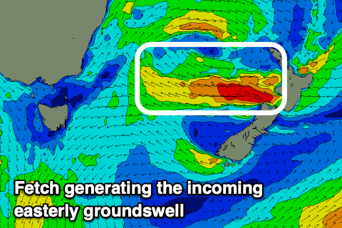
Good run of clean, easterly swell
Eastern Tasmania Surf Forecast by Craig Brokensha (issued Wednesday 24th June)
Best Days: Every day this period
Recap
A mix of E/NE and building SE swells yesterday with favourable winds and to 3-4ft in the morning, building further out of the SE into the afternoon as the south-western arm of a broad low pushed up and past us.
This swell has started to ease today with southern corners the cleanest and to 3-4ft, bigger but wind affected in northern corners.
This week and weekend (June 25 - 28)
With the localised swell now easing back in size, we've got the better quality and cleaner secondary swells out of the east on the way.
With the broad low shifting slowly east we're seeing a good fetch of strong E/SE winds being aimed through our eastern swell window. This should keep open beaches around 4ft on the sets tomorrow, easing a little into the afternoon.
 Over closer to New Zealand our fetch of gale-force E'ly winds are still on track though the fetch looks a touch slimmer and weaker than forecast on Monday. It is long-lived though, persisting from this afternoon through tomorrow before weakening early Friday.
A good E/NE groundswell should be seen from this source, building through Friday and reaching 4-5ft by dark on the sets, easing from a similar size on Saturday morning.
Sunday will then be smaller and easing from 3ft or so on the sets.
Also in the mix on Saturday and Sunday will be some smaller close-range S'ly swell from a cold front pushing up and past us Friday. This will be below the size of the easterly energy though.
Looking at the local winds and a W tending N/NW breeze will create great conditions tomorrow, W/SW all day Friday and then W/NW tending variable on Saturday. Sunday looks similar with W/SW tending variable winds, though more S'ly to the south.
Longer term some small E/SE swell spreading off a small low forming within the cold front moving up past us Friday is likely early next week, but more on this Friday.

