OK south swell for the weekend
Eastern Tasmania Surf Forecast by Craig Brokensha (issued Friday 17th April)
Best Days: Late tomorrow but more so Sunday, possibly Tuesday
Recap
While the swell was reported to be small yesterday, seeing the observations on the southern NSW coast which were in line with forecasts, there should have been 3-4ft sets on the south magnets yesterday, though inconsistent, with the swell easing back today though still offering a small wave for the keen.
This week and weekend (Apr 18 - 24)
Moving into the weekend and we've got the new S'ly groundswell due later tomorrow and Sunday from a strong polar low pushing up and across us this evening and tomorrow.
The forecasts have this low a touch further west and a touch more zonal than forecast earlier in the week and this is a little worrying.
We should still see a fetch of W/SW-SW gales generated right off our south-east corner early tomorrow morning followed by weaker S/SW winds.
 Size wise, later tomorrow may not reveal too much size until dark with sets to 3ft+, with Sunday looking more reliable with easing 3-4ft waves across the swell magnets.
Winds tomorrow afternoon are due to swing more W/SW but still be favourable for south magnets, great Sunday and from the W/NW ahead of NE sea breezes.
Come Monday there isn't expected to be any south swell left and there may be a tiny 1ft+ of N/NE windswell ahead of a strong front.
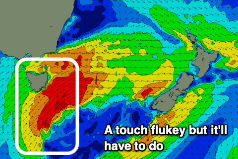
On Tuesday there's the chance for a flukey E/SE swell but only to 2ft or so, generated by an unfavourably aligned fetch of strong E/NE winds south of New Zealand on the weekend. We'll have a closer look at this Monday.
Following this the outlook is void of any major swells as a zonal flow sets up across the south of the country, but check back here Monday for more details. Have a great weekend!

