Fun swells for the coming days
Eastern Tasmania Surf Forecast by Craig Brokensha (issued Wednesday 15th April)
Best Days: Thursday, Friday morning, late Saturday, Sunday
Recap
Good waves yesterday with late Monday's pulse of S'ly groundswell easing back across the coast with offshore winds. This morning was smaller though still fun on the south swell magnets.
This week and weekend (Apr 16 - 19)
Very late today we're likely to see the hints of a new SE groundswell that's due to peak tomorrow morning across the state.
This swell was generated by an intense low that formed south of New Zealand Monday, from the remnants of the polar front linked to Monday/Tuesday's swell.
While not ideally aimed, the strength of severe-gale S-S/SE winds just on the edge of our swell window should produce a good kick in size tomorrow morning, with the northern half of our coast seeing the biggest waves.
Sets to 3-4ft are expected, easing slowly into the afternoon and then down from 2ft+ Friday morning.
 A NW tending W/NW breeze is due across most spots tomorrow, W/SW-SW across some locations to the south into the afternoon with W tending NW winds on Friday.
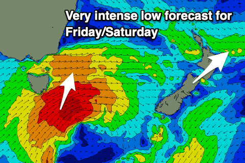
We then look at the weakening low that's forecast to project up and past the south-east corner of the state on Friday and Saturday.
This low will mostly be aimed poorly for us (fetch too west) until it pushes east of us Saturday morning, with no swell due until later in the day and Sunday morning across our region.
Size wise, it's a tricky one, but with a broad fetch of W/SW gales moving through our swell window, followed by weaker and better aligned SW winds, we should see a fun kick in S'ly swell later Saturday to 3-4ft across south swell magnets, easing from a similar size Sunday morning.
Conditions on Saturday afternoon will be OK with SW breezes, better Sunday with a W/NW tending N/NE breeze.
Longer term there's nothing significant on the cards, so make the most of the coming swells.

