Steady run of south swell
Eastern Tasmania Surf Forecast by Craig Brokensha (issued Monday 13th April)
Best Days: Tuesday, Wednesday morning, Thursday, Friday morning, Sunday
Recap
A small S'ly swell for Saturday but not much in regards to size, better yesterday with a kick in size after an afternoon change Saturday, clean and easing through the day.
Today we fell between swells early but a new S'ly groundswell should have kicked this afternoon, with it due to offer fun waves over the coming days.
This weekend and week (Apr 14 - 19)
A broad polar front moving through our swell window the last couple of days has generated a good S'ly groundswell that should have kicked this afternoon and will ease back from a fun 3-4ft tomorrow morning.
Wednesday will see the swell ease off further from 2-3ft, ahead of a new SE groundswell on Thursday.
Coming back to the local winds and we should see clean conditions all day tomorrow, W/NW-NW, with Wednesday playing out similar with NW offshores.
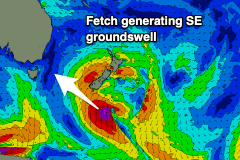
 Moving into Thursday, and the new SE groundswell is due to be generated by the remnants of the front linked to today's swell, with a deep low forming south of New Zealand this evening, projecting a short-lived fetch of severe-gale to storm-force S'ly winds on the edge of our swell window.
While not ideally aimed we should hopefully see sets to 3-4ft across the coast, easing back quickly Friday from 2ft+ owing to the short-lived nature of the low.
Offshore winds will persist out of the NW tending W/NW on Thursday, gusty W'ly on Friday.
Moving into the weekend and a significant low is forecast to form south-west of us Friday, with it moving slowly east and then projecting a fetch of W/SW gales past our south-east corner Saturday morning, angling more SW through the day.
While not ideally aimed, the strength and breadth of the fetch should hopefully generate a good S'ly swell for later Saturday and more so Sunday to 3-4ft across south swell magnets. We'll take a closer look at this swell source on Wednesday though.

