S'ly swell to increase in energy from tomorrow
Eastern Tasmania Surf Forecast by Craig Brokensha (issued Friday 10th April)
Best Days: Sunday morning, Monday, Tuesday, Wednesday
Recap
Nothing to surf yesterday or today with the swell bottoming out.
This weekend and week (Apr 11 - 17)
Our small pulse of acute S'ly groundswell for tomorrow is still on track, with the intense but short-lived polar low forming south-west of us yesterday, generating a fetch of severe-gale to storm-force W-W/NW winds.
While not ideally in our swell window we should see 2ft sets across the south swell magnets through the day, with a morning W/NW offshore, shifting W/SW ahead of a stronger mid-afternoon S'ly change.
 This change will be linked to a low moving across us and then projecting up the southern NSW coast, with local strong S'ly winds kicking up a small local windswell.
This will be more so overnight and ease rapidly Sunday with sets to 3ft or so, easing through the day. Winds will be favourable and out of the W most of the day, so try those south magnets through the morning before it eases.
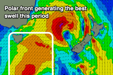
Of greater importance is the better follow up S'ly groundswell for Monday and Tuesday, generated by a good polar front pushing up and past us on Sunday.
A broad fetch of strong S/SW winds will be generated in our southern swell window, with the swell due to build through Monday and likely peak later in the afternoon, then easing back slowly through Tuesday.
Monday morning looks to be 3ft or so, with the groundswell kicking later to 3-4ft on the south swell magnets and then easing from a similar 3-4ft Tuesday morning and then 2ft+ Wednesday.
Winds look favourable and offshore each morning, giving into afternoon sea breezes Monday and Wednesday, but all day offshore Tuesday. Longer term there's nothing too major on the cards besides some inconsistent SE groundswell for later week, but more on this Monday. Have a great weekend!

