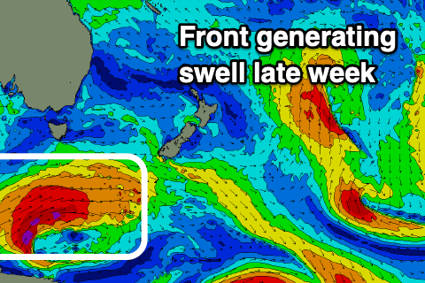
South swells on the way, followed by east
Eastern Tasmania Surf Forecast by Craig Brokensha (issued Monday 16th March)
Best Days: Friday, early Saturday, Monday morning
Recap
A kick in S'ly swell on Saturday but with less than ideal winds for spots seeing the size, cleaner but small and to 2ft on the south magnets yesterday.
Today a new S'ly groundswell has provided a pulse to 2-3ft, while weirdly under-performing across the South Arm.
This week and weekend (Mar 17 - 22)
Looking at the week ahead and the coming days aren't expected to offer much in the way of surf with the swell from today dropping back from 1ft to maybe 2ft on the south swell magnets early.
Some small E'ly swell may spread off a poorly aligned fetch of SE winds in the northern Tasman Sea, but I wouldn't expect anything above 1-2ft across open beaches Wednesday and Thursday, easing Friday.
Of greater importance is a good S'ly groundswell due Friday, with a couple of smaller back up pulses into the weekend and early next week.
 A series of strong polar fronts are firing up under the influence of a strengthening node of the Long Wave Trough pushing east, with the first system being best for us.
A great fetch of gale to severe-gale W/SW winds will be projected through our swell window over the coming days, with the S'ly groundswell building Friday and peaking into the afternoon to a solid 4ft across the south magnets.
Winds look NW-W/NW favouring the south magnets all day, with a SW tending SE change on Saturday as the S'ly swell eases.
A small spike in short-range S'ly swell is also likely on Saturday with sets to 3ft on the south magnets.
Longer term more distant and weaker polar fronts look to generate inconsistent 2-3ft levels of S'ly groundswell through Sunday and Monday while beyond that a deepening inland surface trough and low looks to bring a building E/NE swell with at this stage onshore winds. More on this Wednesday though.

