Upgrade in the size and quality of south swell
Eastern Tasmania Surf Forecast by Craig Brokensha (issued Wednesday 25th February)
Best Days: South swell magnets Friday, Saturday and Sunday
Recap
Tiny surf yesterday and similar today, with more of the same on the cards for tomorrow.
This week and weekend (Feb 26 – Mar 1)
As touched on last update we've got a tricky and flukey run of heavily diffracted southerly groundswell due this period with the Southern Ocean storm track firing up west and south of the state.
Tomorrow will be flat, but moving into Friday, we should see some new S'ly groundswell building across south swell magnets, generated by a weakening frontal progression pushing across us tomorrow.
 A fetch of strong to near gale-force W/SW winds will be generated just within our swell window, with a building swell due through the day, reaching 3-4ft across south swell magnets into the afternoon and then easing from 3ft or so Saturday morning.
All other beaches are due to be tiny to flat.
Winds look good in the morning Friday, W/NW, but giving into E/NE sea breezes ahead of possible late swing back to the NW. So keep an eye on those south magnets.
Saturday looks good again with W/NW offshores ahead of N/NE sea breezes.
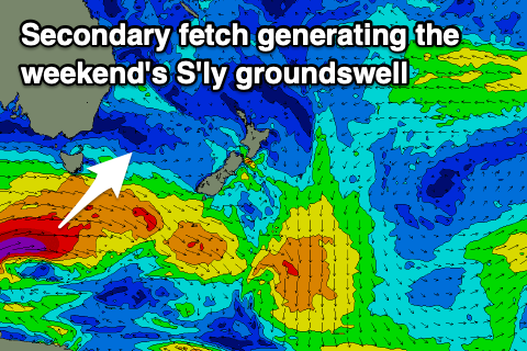
 Now, moving into Sunday and we've got an upgrade in a secondary front moving in behind the weakening progression tomorrow.
A great fetch of severe-gale to storm-force W/SW winds are due to be generated in our southern swell window, producing a larger S'ly groundswell pulse for Sunday, peaking into the afternoon around 4-5ft across south swell magnets. Winds are looking better as well with a W/NW tending variable breeze Sunday, less favourable and out of the south as the swell eases Monday.
Longer term we've got an even better and slow moving polar frontal progression forecast to develop more east and in our swell window early next week.
This should produce a larger S'ly groundswell event mid-week, but we'll look at this closer on Friday.

