Good run of waves this week
Eastern Tasmania Surf Forecast by Craig Brokensha (issued Monday 20th January)
Best Days: Southern corners tomorrow, northern corners Wednesday and Thursday, dawn Friday
Recap
Poor and choppy conditions on the coast Saturday, a bit better Sunday with peaky and cleaner conditions and 2-3ft of south-east swell.
Today onshores kicked back in with poor conditions and sloppy surf.
This week and weekend (Jan 21 - 26)
A surface trough that's currently drawn out from east of us to off the southern NSW coast is generating a weak fetch of S/SE winds across our coast and the weak windswell we're seeing today.
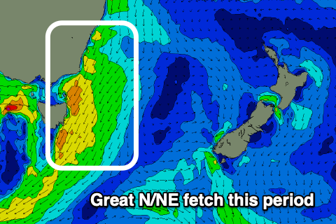
 A better infeed of N/NE winds should generate a better NE swell tomorrow and Wednesday, inconsistent at times but a good 3ft, easing slowly from Wednesday morning.
S/SW tending SE winds will favour southern corners tomorrow, less favourable and N/NW tending stronger N/NE on Wednesday.
As touched on in Friday's update, a mid-latitude low moving in from the west, squeezing a strong high in the Tasman will produce a strengthening fetch of N/NE winds through our north-eastern swell window Wednesday afternoon and evening, producing a good spike in new N/NE swell Thursday to 4ft, easing through the day as N/NW winds slowly strengthen. This will favour more open beaches and northern corners.
There isn't expected to be much size left into Friday with fading 1-2ft sets and clean conditions.
Following the waves this week, there's nothing too significant on the cards for next week as the westerly storm track starts to become more active. Therefore make the most of the coming days of waves.


Comments
Staying in St Helens till Friday. Any tips for this swell nearby to here?
Few options Wednesday but better Thursday if you head out beer barrel or perrons way. Aim for those corners clean in nw wind Thursday
Yeah peron mate clean ... travel also