North followed by south
Eastern Tasmania Surf Forecast by Craig Brokensha (issued Friday 20th December)
Best Days: North-east swell magnets tomorrow morning, south swell magnets late Sunday and Monday until mid-afternoon
Recap
Tiny waves yesterday and today with nothing of real substance.
This week and next weekend (Dec 21 - 27)
Our N/NE windswell for tomorrow is on track with a great fetch of strong N/NE winds to due develop in our northern swell window this evening, retreating early morning tomorrow but still sitting just off to our north-east.
This should produce a good N/NE swell tomorrow to 3ft to likely 4ft across north-east swell magnets, easing through the afternoon with a dawn W/NW breeze shifting S/SE shortly thereafter and then E/NE into the afternoon, NE later.
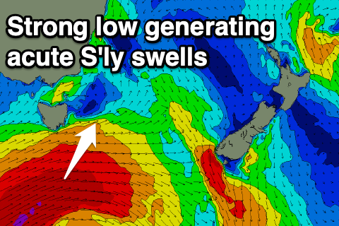
We then look at the swell off the significant low moving under the state this weekend.
 The low will generate an amazing fetch of storm-force W/SW winds aimed out of our swell window, but come tomorrow evening and Saturday, we'll see our swell window opened up to a weakening fetch of severe-gale W/SW-SW winds.
This will produce a good S'ly groundswell for Monday, but come Sunday afternoon, a refracted S'ly groundswell should build, kicking to 3-4ft late in the day across south swell magnets, with Monday seeing 4-5ft+ sets.
The swell will be acute and long-period so expect a wide variation in size and funky focussing or steering away at some spots.
Winds on Sunday afternoon look to swing NE late, favouring south swell magnets, with a N/NE tending E/NE breeze Monday ahead of an afternoon S/SE change.
This change will leave poor and lingering S/SW tending SE winds Tuesday as the S'ly groundswell eases from 3ft+.
Come Christmas Day there may be a small 2ft leftover wave across south swell magnets with nothing too significant after. Therefore make the most of the coming swells. Have a great weekend!

