Fun N/NE windswell this week

Eastern Tasmania Surf Forecast by Craig Brokensha (issued Monday 18th November)
Best Days: South magnets Wednesday, Thursday afternoon, early Friday
Recap
Tiny Saturday with a little lift in south swell yesterday to 1-2ft on the south swell magnets, fading back to near flat conditions today.
This weekend and next week (Nov 19 - 24)
A couple of flukey S'ly swells are possible across south swell magnets Wednesday and Thursday, but on the later a N/NE windswell will be much more dominant.
The S'ly swells will be generated by a front/low that's formed south of us, with a broad but relatively weak fetch of strong W/SW winds spread out through our southern swell window.
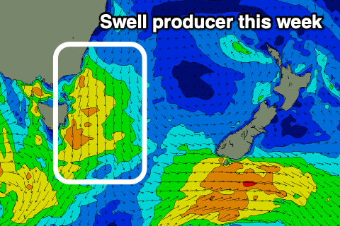 A slight intensification of W/SW gales at the lows core tomorrow morning should produce a little better pulse for later Wednesday and Thursday morning.
Size wise, tomorrow is expected to be small to tiny and only 1-2ft max on the south swell magnets a bit better and to 2ft Wednesday, easing from 2ft Thursday morning.
Winds tomorrow are average for south swell magnets with a dawn W/SW tending S/SE breeze, E'ly into the afternoon. Wednesday will be cleaner with light N/NW tending fresh N/NE winds.
These winds will strengthen further overnight and into Thursday morning, kicking up a quick spike in N/NE windswell that should build to 3ft+ across north-east swell magnets through the day as winds shift from the N'th in the morning to the NW through the afternoon and S'ly later. This will favour the north-east magnets for the late.
Come Friday morning there isn't expected to be much size left, with facing 2ft sets across north-east magnets with a variable tending NE breeze.
Longer term the outlook is void of swell so aim for a surf Thursday afternoon and evening with the change.