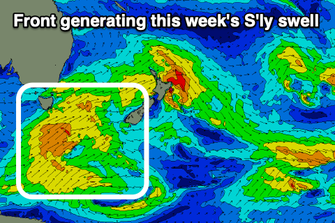
Fun southerly swell this week
Eastern Tasmania Surf Forecast by Craig Brokensha (issued Monday 23rd September)
Best Days: Wednesday afternoon south swell magnets, Thursday morning south swell magnets
Recap
A temporary drop in NE swell Saturday morning before kicking up large into the afternoon again, but easing rapidly overnight and back from the 3ft range on the sets yesterday but much cleaner.
Today the NE swell was replaced by a S/SE swell from a small low that formed under us on the weekend, generating 2-3ft of swell.
This week and weekend (Sep 24 - 29)
Today's spike in S/SE swell will be all but gone tomorrow and then we look to a new mid-period S'ly swell due into Wednesday afternoon, easing Thursday.
This will be generated by a strengthening but relatively weak polar front south of us, projecting a fetch of S/SW winds through our southern swell window and up past us Tuesday evening.
 The swell should build through the day and peak into the afternoon to a good 3ft across south swell magnets, easing back from 2-3ft on Thursday morning.
Winds on Wednesday will be offshore from the W/SW in the morning, but swinging fresh N/NE into the afternoon, favouring those south magnets, with a W/NW tending N/NE and then late NW breeze Thursday as the swell eases.
Following this the outlook remains mediocre until early next week, when another strong polar front may generate a fun S'ly groundswell, but probably not to the consistency of the swell mid-week.
More on this Wednesday.

