Fading S swell and flukey NE swell
Eastern Tasmania Surf Forecast by Craig Brokensha (issued Friday 30th August)
Best Days: Saturday morning south swell magnets, Tuesday afternoon and early Wednesday for keen surfers
Recap
A small kick in southerly swell yesterday, but today's stronger and better aligned swell has come in nicely with clean conditions and good waves on the coast.
Today’s Forecaster Notes are brought to you by Rip Curl
This weekend and next week (Aug 31 – Sep 6)
Today's pulse of S'ly groundswell is expected to drop back in size through this afternoon and further tomorrow from 2ft to possibly 3ft early at south swell magnets.
Strengthening N/NW winds will favour these locations while also possibly generating a small 1-2ft N/NE windswell wave late in the day.
 This swell will be tiny and all but gone by Sunday as winds swing from N/NW to N/NE.
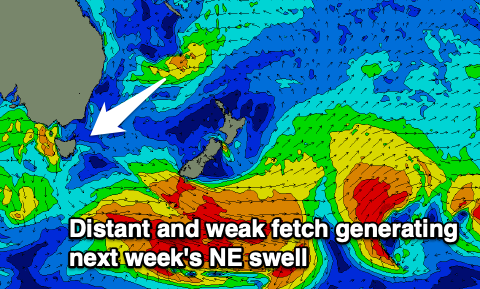
Early next week won't go flat but will likely be tiny with a hint of NE swell from a surface trough off the NSW coast, ahead of a better but small and inconsistent NE swell Tuesday afternoon.
The source of this swell will be a fetch of strong E/NE winds feeding in around the north-east flank of a trough sitting south of New Caledonia.
Size wise we're not expecting to see much size above 2ft out of the NE Tuesday afternoon, easing from 1-2ft Wednesday.
Winds look favourable and out of the W/NW, but keep your expectations low regarding this swell.
Longer term there's noting too significant on the cards, but more on this Monday. Have a great weekend!

