Very active period continues
Eastern Tasmania Surf Forecast by Craig Brokensha (issued Monday 5th August)
Best Days: Tuesday, Wednesday morning, Thursday afternoon, Saturday protected spots, Sunday, Monday, Tuesday
Recap
Small leftover 1-2ft waves on Saturday across south magnets, but a much better S'ly groundswell filled in Sunday with clean conditions and pumping waves on the coast.
This morning the swell was still up and conditions great again.
Today’s Forecaster Notes are brought to you by Rip Curl
This week and weekend (Aug 6 - 11)
Our new pulse of S/SE groundswell for tomorrow is still on track with a great fetch of severe-gale to storm-force S/SE winds being generated at the base of the storm linked to yesterday's and today's swell over the weekend.
We should see south facing beaches coming in at 3-5ft along with great NW tending N/NW winds.
Wednesday morning will be good with a NW tending W/NW offshore and easing surf from a smaller 2-3ft on the sets, though inconsistent.
Moving into Thursday we've got a dynamic outlook with a deepening mid-latitude low due to move in, bringing a wild variation in winds, E/NE and onshore early but then swinging W/NW through the day as the lows centre moves over us.
There should be a small and inconsistent S/SE groundswell in the mix as well to 2-3ft across south swell magnets into the afternoon, cleaning up with the NW change.
 As the low continues to drift south-east into Friday a fetch of strong to gale-force S/SE winds are forecast to be projected up and into our East Coast into the afternoon, kicking up a large and stormy increase in S/SE swell on Saturday that at current forecasts looks to come in around 8ft+ across the northern half of the coast along with strong S/SW winds.
This would favour protected spots through the day, with more favourable SW winds on Sunday as the swell eases away, dropping back from 4-5ft+ Sunday morning.
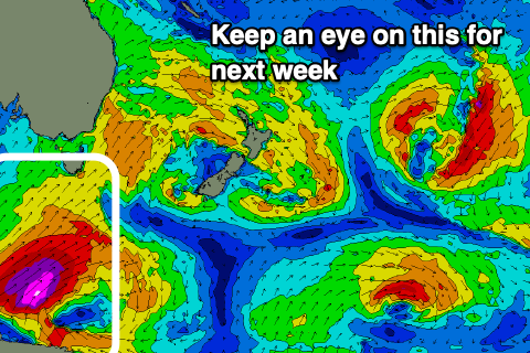
Before things get any time to settle into early next week, a vigorous polar frontal system is due to form over the weekend, projecting a fetch of severe-gale to storm-force SW winds up through our southern swell window and towards the Tasman Sea, producing a large and powerful S'ly groundswell for Monday, building through the day and peaking later before easing slowly Tuesday and Wednesday.
Size wise at this stage we're looking at 8ft of S'ly groundswell with W/SW-SW winds. We'll go over this again and the weekend's swell on Wednesday.

