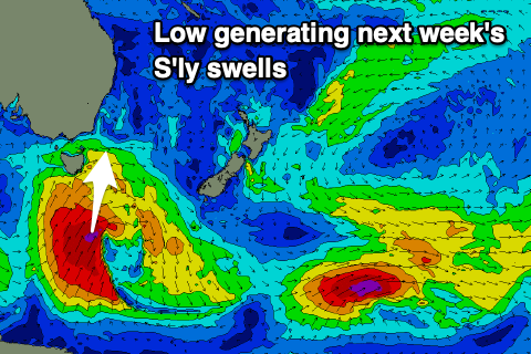
New S'ly swells for next week
Eastern Tasmania Surf Forecast by Craig Brokensha (issued Friday 26th July)
Best Days: Tuesday protected spots, Wednesday morning, Thursday morning
Recap
A continuation of tiny to flat surf.
Today’s Forecaster Notes are brought to you by Rip Curl
This weekend and next week (Jul 27 – Aug 2)
The weekend won't offer any decent surf with tiny background levels of E'ly swell maybe to 1ft.
The dynamics of next week's S'ly change and Tasman Low have changed, with now a mix of a strong polar low and then unfavourably aligned low over New Zealand on the cards.
 This will see the action swing from our south-eastern swell window more to the south, with the polar low due to generate a good and prolonged S'ly swell event.
As the low develops and moves east on Sunday evening and Monday, a fetch of gale to severe-gale S/SW winds will be projected through our southern swell window, generating a moderate sized S'ly groundswell pulse for Tuesday morning to 3-5ft across south swell magnets, easing a touch through the day.
A trailing fetch of S'ly gales on the polar shelf Monday afternoon and evening should produce a secondary reinforcing S'ly groundswell for Wednesday, maintaining 4ft sets at south swell magnets, easing through the day and then down quickly from 3ft Thursday morning.
Winds look generally favourable besides Tuesday morning with a S/SW-SW breeze, better for those south swell magnets Wednesday morning with a W/SW offshore, S/SE into the afternoon. Thursday morning will be great with a W/NW offshore, again shifting S/SE into the afternoon.
Longer term another S'ly groundswell is possible next weekend, but more on this Monday. Have a great weekend!

