Small S pulses ahead of a larger swell early next week
Eastern Tasmania Surf Forecast by Craig Brokensha (issued Wednesday 10th July)
Best Days: South magnets tomorrow and dawn Sunday, Monday afternoon, south magnets Tuesday
Recap
Yesterday's new S'ly swell came in well with clean 2-3ft waves on the south magnets, though easing back today to a tiny 1ft.
Today’s Forecaster Notes are brought to you by Rip Curl
This week and next (Jul 11 - 19)
A secondary pulse of inconsistent S/SE groundswell from the same storm that generated yesterday's swell is due tomorrow, with inconsistent 2ft sets likely on the south magnets with gusty W/NW winds.
This will fade into Friday and there's nothing decent due until Sunday morning.
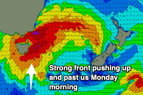
 An initial cold front pushing up and past us Saturday afternoon will kick up a short-range S'ly swell to 3ft at south facing beaches (tiny elsewhere) late in the day but with strong S/SW-SW winds.
Winds are expected to go back to the W/NW temporarily early Sunday ahead of a much more significant front, straightening out from the W/SW through the day. South facing beaches will hopefully have a 2ft wave at dawn, but become flat through the day, so aim for the early.
A larger and more powerful S'ly groundswell is due to fill in on Monday, as a strong polar front pushes up and past us, generating a great fetch of SW-S/SW gales Sunday evening and Monday morning.
With this the swell is likely to be largest and strongest into the afternoon, building to 5-6ft at south facing beaches and with the front moving off to the east, we'll see morning SW winds, straightening out from the W/SW into the afternoon.
A W/NW breeze is then expected on Tuesday morning but with the swell dropping right back overnight and further from 3ft+.
Longer term we may see another front pushing up past us Tuesday afternoon, generating a small S'ly swell mid-next week, but we'll have a closer look at this Friday.

