Great run of NE/ENE swell but inconsistent
Eastern Tasmania Surf Forecast by Craig Brokensha (issued Monday 1st July)
Best Days: Every day this period (northern corners Saturday)
Recap
Tiny start to Saturday ahead of a building N/NE windswell later which cleaned up and peaked around 2-3ft Sunday morning, tiny into the afternoon.
Today is tiny and we're in between swells, with a new NE groundswell due to arrive overnight.
Today’s Forecaster Notes are brought to you by Rip Curl
This week and weekend (Jul 1 - 7)
We look ahead towards tomorrow's NE groundswell event, and tracking the swell from northern NSW, down to southern NSW and then to us, it's been a little delayed.
 We should see the swell at dawn tomorrow morning but a peak is likely into the afternoon with building sets from an inconsistent 3-4ft upwards towards 4-5ft into the afternoon, if not for the very rare 6ft bomb. This swell was very inconsistent across southern NSW and I'd expect even less consistency across our region.
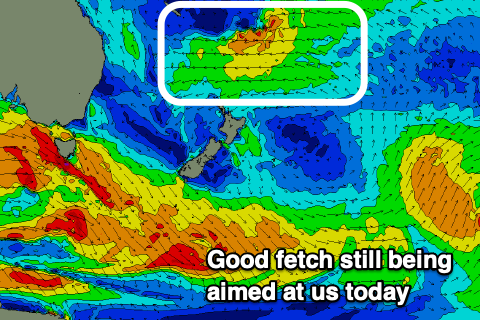
The swell is due to ease back slightly from Wednesday but a fetch of strong E/NE trades extending north and east of New Zealand are continuing to generate moderate levels of NE trade-swell for us which should hold into the end of the week and then start easing through the weekend.
It'll be inconsistent but Wednesday looks to drop slightly from 4-5ft, with the swell remaining around an inconsistent and lully 3-4ft into the end of the week, easing into Saturday afternoon.
Winds tomorrow will be fresh and gusty from the W/NW to W/SW, shifting SW to SE on Wednesday. Thursday morning looks great again with a W/SW offshore, E/SE into the afternoon, similar Friday morning but with NE sea breezes.
Average N/NE winds will kick in on Saturday but then shift N/NW on Sunday as the swell fades.
Longer term there's nothing too significant with the distant E/NE swell due to keep easing, so make the most of the coming days, but remember patience will be the key.

