Large S'ly groundswell to end the week
Eastern Tasmania Surf Forecast by Craig Brokensha (issued Wednesday 5th June)
Best Days: Thursday, Friday morning, Saturday south swell magnets
Recap
An average windswelly wave on offer yesterday with poor winds, much better today with cleaner conditions and 3ft of leftover S/SE swell.
Today’s Forecaster Notes are brought to you by Rip Curl
This week and weekend (Jun 6 - 9)
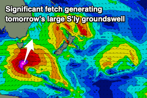
We then look towards tomorrow large and powerful S'ly groundswell, with a very intense storm currently passing under the state, generating a fetch of severe-gale to storm-force SW tending S/SW winds while projecting up towards the Tasman Sea.
 A large, long-period bur short-lived S'ly groundswell is due off this system, building rapidly from late morning tomorrow and peaking around 6-8ft at south facing beaches into the afternoon.
Winds look favourable for most of the day, moderate out of the W/SW, tending variable into the afternoon if not W/NW late, while Friday looks great with a W/NW tending variable breeze.
The S'ly groundswell will ease rapidly though owing to the low moving off quickly across New Zealand, leaving easing 4ft sets Friday morning across magnets, small to tiny into the afternoon.
On the weekend, a small pulse of inconsistent S'ly groundswell should keep south facing beaches topped up with 2-3ft sets Saturday, generated by a late forming fetch of polar severe-gale to storm-force W'ly winds.
Conditions will remain clean with a NW offshore, tiny Sunday as the swell fades.
Longer term, besides a small to tiny pulse of N'ly windswell Monday, there's nothing too significant on the cards so make the most of the coming S'ly swells.

