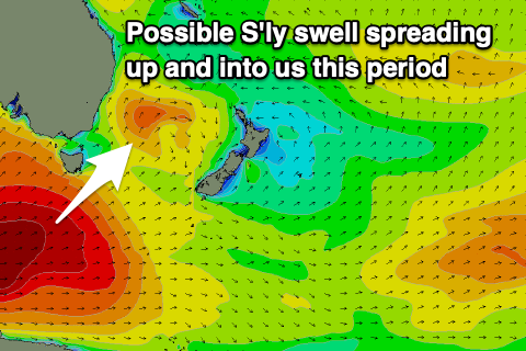
Flukey south swell the only source of energy
Eastern Tasmania Surf Forecast by Craig Brokensha (issued Friday 10th May)
Best Days: No great days, try south magnets late Sunday and Monday morning
Recap
Good clean waves with an easing E'ly swell yesterday from 3ft on the sets, tiny and choppy today with a freshening S'ly wind.
Today’s Forecaster Notes are brought to you by Rip Curl
This weekend and next week (May 11 - 17)
Our S'ly swell from a low forming off our coast today was downgraded on Wednesday and now it's been downgraded even more with it forming further away, up the southern NSW coast.
 Come tomorrow there isn't expected to be any surfable swell, while we then look to the only other real swell, that being a very flukey refracted S'ly groundswell from the Southern Ocean.
Currently a vigorous polar frontal progression is generating large long-period SW groundswell energy for the West and Southern coasts Sunday/Monday, and we may see some small energy rounding our south-east corner.
Any increase in size should be seen later Sunday and Monday morning to 2ft to possibly 3ft at south magnets (tiny to flat elsewhere), easing through Monday afternoon and tiny Tuesday.
Winds look great for south magnets with a variable breeze Sunday afternoon, if not from the W/NW, and then strengthening NW winds Monday.
Longer term a surface trough sliding up from the south-west across us later next week may form into a low, but we'll have to have another look at this Monday as the models are divergent on this. Have a great weekend!

