Make the most of the easing east swell
Eastern Tasmania Surf Forecast by Craig Brokensha (issued Wednesday 8th May)
Best Days: Thursday morning, south magnets late Sunday and Monday morning
Recap
Good easing levels of SE swell yesterday from 3-5ft, while this morning we fell in between swells but a new E/NE swell should have reached 3-4ft across open beaches during the day.
Today’s Forecaster Notes are brought to you by Rip Curl
This week and weekend (May 9 - 12)
Today's E/NE swell should provide fun waves into tomorrow morning while swinging more E/SE in direction and easing back from 3ft+ across open beaches. Winds will be great and offshore from the W/NW early, tending N/NW and strengthening into the afternoon.
This will be ahead of a deepening trough moving in from the west, bringing a gusty S'ly change early Friday which now isn't expected to bring any decent swell with it. The low now looks to evolve off the NSW coast and with this we're not due to see any decent S'ly swell at all, with flat conditions into the weekend.
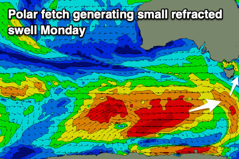
 The only other source of swell looks to be from some refracted S'ly groundswell energy linked to a vigorous polar frontal system moving under the country over the coming days. A fetch of severe-gale to storm-force W'ly winds should produce a flukey long-period S'ly groundswell, building later Sunday and peaking Monday morning to possibly 2-3ft across south magnets.
Winds will be great and offshore from the NW all day, favouring these south magnets as the swell fades through the day.
Longer term there's unfortunately nothing significant on the cards, so make the most of tomorrow morning's waves.

