Small N/NE windswell followed by a large E'ly swell
Eastern Tasmania Surf Forecast by Craig Brokensha (issued Wednesday 1st May)
Best Days: Friday, protected spots Monday and Tuesday, Wednesday morning
Recap
Small easing lines out of the S'th yesterday to 1-2ft across south magnets, while today the swell has increased out of the NE to 2-3ft with variable winds.
Today’s Forecaster Notes are brought to you by Rip Curl
This week and weekend (May 2 - 5)
Today's first pulse of N/NE swell was generated by a great fetch of N/NE winds off the southern NSW coast and we'll see it drop overnight, though weak N/NE winds off our coast should keep smaller 2ft sets hitting north-east magnets.
Conditions won't be ideal with early light N'ly winds, freshening through the day.
 A slight intensification of the N/NE fetch overnight tomorrow should produce a touch more energy for Friday morning, but with the fetch also moving east away from us, it looks to come in at 2-3ft across north-east magnets early, easing through the day with fresh N/NW tending NW winds.
Come Saturday there isn't expected to be much left in the tank and early offshore winds will give into a S'ly change.
A small increase in S'ly windswell is due off the change, peaking Sunday morning and easing from 2-3ft across south facing beaches though with S/SE winds.
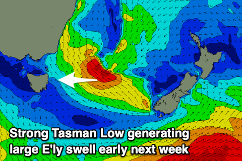
The front linked to the weekend's change will form into a strong Tasman Low between us and New Zealand, with a great fetch of strong to gale-force E/SE-SE winds forecast to be projected through our eastern swell window.
We should see a large E/SE groundswell building through Monday, starting more windswelly in the morning and reaching what at this stage looks to be 6-8ft across open beaches later in the day.
Winds will persist out of the S/SE as the low pushes closer to us, but it's forecast to move back inland and dissolved which could result in more favourable S/SW winds Tuesday morning with large levels of easing E'ly swell. We'll have to go over this again on Friday with more confidence.

