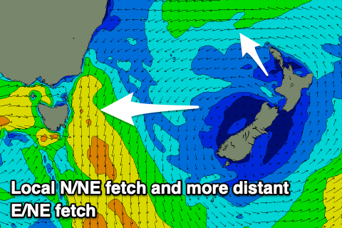
Good swells from the north-eastern quadrant
Eastern Tasmania Surf Forecast by Craig Brokensha (issued Monday 15th April)
Best Days: Northern corners later Wednesday, Thursday north-east magnets, northern corners Sunday, Monday
Recap
A small S'ly swell should have shown at south magnets Saturday though was only reported at 1ft around open beaches, with tiny surf since then.
Today’s Forecaster Notes are brought to you by Rip Curl
This week and weekend (Apr 16 - 21)
A weak fetch of E'ly winds are currently aimed at us, atop a high that's to our south-east. This should of generate a small increase in E/NE windswell this afternoon which will persist tomorrow to 2ft+ but with an early light N'ly wind, freshening from the N/NE through the day.
These N/NE winds will strengthen through tomorrow evening and Wednesday kicking up a building N/NE windswell that should build from 2-3ft in the morning to 3-4ft by late in the day with gusty N/NE winds.
 A cold front moving in from the west will bring a W change on Thursday morning and a drop in N/NE swell from a good 3ft or so. Winds will shift S'ly into the afternoon as the swell continues to fade with Friday seeing a possible small 1-2ft of S'ly swell from the change.
Of greater importance is the back up E/NE trade-swell due into the weekend, with a great fetch of sustained and strong E/NE trades from north of New Zealand.
This trade-fetch will produce a fun E/NE trade-swell from later Friday, building to 2ft at open beaches further Saturday and peaking Sunday to 3ft.
Also in the mix will be some more N/NE windswell from a strong fetch of N/NE winds developing down the coast again, though this looks to be smaller than Wednesday and to 2ft to occasionally 3ft.
Winds as a result will be out of the N/NE, swinging more W/NW on Monday with easing 3ft sets. We'll have a closer look at this Wednesday though.

