Strong N/NE swell for the weekend, fun E/NE swell next week
Eastern Tasmania Surf Forecast by Craig Brokensha (issued Wednesday 3rd April)
Best Days: Later Friday, Saturday, Monday morning, Tuesday morning, Wednesday, Thursday
Recap
Fun clean waves out of the S again yesterday morning, dropping from 2-3ft, while there was still 2ft of swell left into today.
Today’s Forecaster Notes are brought to you by Rip Curl
This week and weekend (Apr 4 - 7)
A S'ly change this afternoon will kick up a weak increase in S'ly windswell tomorrow to possibly 2ft at south swell magnets but with an onshore S/SE tending E/NE breeze.
The E'ly tending E/NE swell due off the ridge moving in behind this change has been downgraded with it sitting further north and out of our swell window, but the N/NE windswell event for Saturday is still on track.
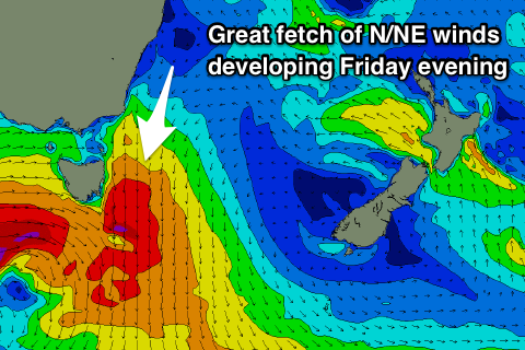
 A vigorous mid-latitude low moving in from the west will squeeze the high, with a great fetch of strong N/NE winds due to develop in our north-eastern swell window tomorrow
The swell will build rapidly Friday from 2ft+ through the morning to 3-4ft by dark, peaking Saturday morning to what looks to be 4-5ft, if not for the odd 6ft cleanup across magnets.
The low will move across us early Saturday morning bringing a straight W'ly change, tending variable ahead of E'ly sea breezes as the N/NE swell drops rapidly.
Come Sunday there isn't due to be any major size left at all, with clean though small to tiny leftovers.
From later Sunday but more so Monday a fun new E/NE swell should start to build, generated by a weak low forming in the northern Tasman Sea.
A small fetch of strong E/SE winds exiting New Zealand's Cook Strait will broaden through the weekend before the low moves slightly west and strengthens temporarily Monday. This should produce a prolonged E/NE swell event, building Monday to 2ft across open beaches, with the best pulse mid-week to 3ft Wednesday afternoon and Thursday. Winds look favourable and offshore each morning, but more on this Friday.

