Small mix of E/NE and NE swells over the coming days
Eastern Tasmania Surf Forecast by Craig Brokensha (issued Monday 4th March)
Best Days: Tuesday morning, Wednesday, Thursday morning
Recap
A drop in N/NE windswell from Friday afternoon into Saturday morning, but kicking again into the afternoon and coming in at a fun 2-3ft yesterday.
The swell has dropped back into this morning to 1-2ft with a variable S'ly wind that is now NE.
Today’s Forecaster Notes are brought to you by Rip Curl
This week and weekend (Mar 2 - 8)
With the N/NE windswell fading away we look towards the inconsistent E/NE groundswell due from Tropical Cyclone Pola.
The swell has hit the Gold Coast strongly this afternoon but probably won't provide any noticeable size before dark across our region.
 We should see the swell tomorrow though with infrequent sets to 2-3ft across open beaches, easing through the day and fading Wednesday from 1-2ft.
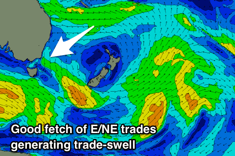
Some fun reinforcing mid-period NE swell from a good fetch of E/NE trades angling down towards us from the Coral Sea is due Wednesday.
We should see this swell fill in through the day and kick back to 2-3ft, possibly even by morning, easing slowly from 2ft Thursday morning.
Winds over the coming days will be generally favourable, offshore out of the W early tomorrow, tending E and then NE into the afternoon, S/SW tending SW Wednesday morning before reverting back to the S into the afternoon.
Thursday will be clean again through the morning with a W/NW offshore and NE sea breezes.
Once the NE trade-swell fades there's nothing significant at all on the cards for us for the forecast period as the westerly storm track starts to fire up. Therefore make the most of the coming days waves, even though small and inconsistent.

