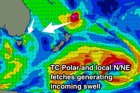
Fun N/NE windswell and E/NE groundswell inbound
Eastern Tasmania Surf Forecast by Craig Brokensha (issued Wednesday 27th February)
Best Days: Saturday and Sunday mornings, Monday, Tuesday
Recap
Tiny to flat conditions with average winds yesterday, lighter today.
Today’s Forecaster Notes are brought to you by Rip Curl
This week and weekend (Feb 28 – Mar 3)
As touched on last update we've got a fun N/NE windswell event due from later this week into early next week.
A strong and slow moving high will be squeezed by a weak surface trough over Victoria and then a stronger cold front through the weekend, weakening back to a trough.
 We'll see a weak fetch of N/NE winds developing in our swell window from tomorrow afternoon and evening, strengthen Friday afternoon but looking best through Saturday and Sunday ahead of the trough moving east across us.
Small levels of N/NE windswell to a weak 1-2ft are expected Friday morning, building later in the day to 2ft+, with Saturday coming in at 2-3ft, building later to 3ft+, holding this size all day Sunday.
The swell will then ease quickly in the wake of an overnight change from 2ft.
Winds Friday will be average and out of the N-N/NE, with a N/NW tending N/NE breeze both Saturday and Sunday. Monday will see offshore SW winds, swinging NE into the afternoon.
As the N/NE windswell fades on Monday we should see a new inconsistent E/NE groundswell filling in, generated by Tropical Cyclone Pola which is currently just east of Fiji.
Pola is expected to deepen significantly while drifting south and squeezing the north-eastern flank of the high in the Tasman, with a fetch of strong to gale-force E/SE winds being generated just within our swell window.
A small inconsistent E/NE groundswell should spread down off this source and building Monday to 2-3ft at open beaches, easing from a similar size Tuesday with NW winds. More on this Friday.

