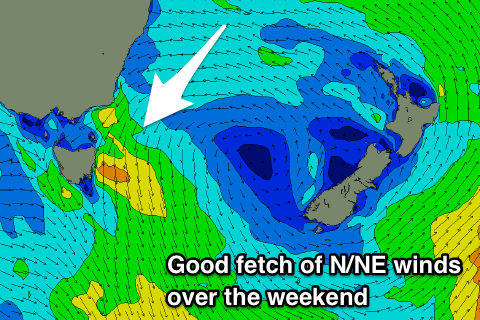
Fun N/NE windswell energy from Friday
Eastern Tasmania Surf Forecast by Craig Brokensha (issued Monday 25th February)
Best Days: Saturday morning, Sunday northern corners, Monday southern corners
Recap
Inconsistent levels of NE groundswell from Tropical Cyclone Oma and an easing SE swell from Friday, with southerly winds favouring southern corners Saturday. A new S'ly swell was seen Sunday with light offshore winds creating good conditions across south magnets.
Today the swell should have been easing out of the SE but was reported from the NE.
Today’s Forecaster Notes are brought to you by Rip Curl
This week and weekend (Feb 25 – Mar 3)
There isn't expected to be much in the way of swell out of the north or south tomorrow, and a weak S'ly change will kick up a very tiny and weak S'ly windswell. There may be a small 1ft to occasionally 2ft wave on Wednesday morning across south magnets, easing through the day but a S'ly tending E/NE wind will create average conditions.
Of greater importance is a small prolonged NE windswell event from later week through the weekend, fading early next week.
 A strong and stationary high in the Tasman Sea will be squeezed by a slow moving and stalling surface trough over Victoria.
A persistent fetch of strong N/NE winds should see some fun persistent N/NE swell developing down the coast peaking through the weekend around 3ft across north-east facing beaches.
Winds will generally be from the N'th each morning, fresher N/NE into the afternoons, though NW Saturday morning and then S/SE Monday as a change moves through. This change will herald the end of the swell event with easing sets from 2ft to occasionally 3ft.
Beyond this there's nothing too significant on the cards so make the most of the coming swell.

