Flukey N/NE groundswell and more reliable SE energy
Eastern Tasmania Surf Forecast by Craig Brokensha (issued Monday 18th February)
Best Days: Friday morning, Saturday morning, Sunday morning
Recap
Tiny surf over the weekend and into today with no real signs of the expected S'ly swell yesterday.
Today’s Forecaster Notes are brought to you by Rip Curl
This week and weekend (Feb 19 - 24)
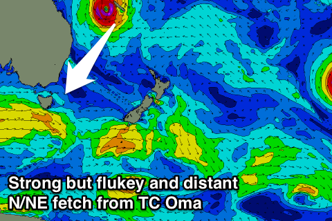
The coming forecast period is super flukey when looking at the N/NE groundswell event from Tropical Cyclone Oma.
The models are still divergent on the eventual track of Oma after it moves south-west towards the Queensland coast, but before this we'll see a tight but slow moving fetch of severe-gale to storm-force N/NE winds aimed through our northern swell window.
While only small in scope, the strengths are significant and we should see some very inconsistent and acute N/NE groundswell arriving later Thursday but Friday is the best opportunity to see this swell in the water.
 As we don't get long-period N/NE groundswell events from this direction often at all it will likely to funky things on the coast and may be focussing into some north facing breaks, but missing others.
The swell should build through Friday to an inconsistent 3-4ft into the afternoon. Also in the mix should be a fun and more reliable SE groundswell from a fetch of SE gales south of New Zealand this afternoon through tomorrow.
Fun inconsistent sets to 3ft should build through the afternoon, though early S/SW winds are expected to shift E through the day.
Both swells are due to ease back through Saturday from the 3ft range with a good offshore W/NW wind, giving into a SE change.
Longer term the outlook is uncertain due to the uncertainty of Oma into the weekend, so check back here Wednesday for an idea on what we're looking at.

