Small S'ly swell for the weekend, rare cyclone swell possible later
Eastern Tasmania Surf Forecast by Craig Brokensha (issued Friday 15th February)
Best Days: South magnets Sunday morning, later next week
Recap
A small, clean and fun pulse of S'ly swell on the magnets yesterday, fading back to a tiny 0.5-1ft today.
Today’s Forecaster Notes are brought to you by Rip Curl
This week and weekend (Feb 14 - 17)
Tomorrow should remain tiny, but our fun pulse of S'ly swell for Sunday morning is still on track, generated by a weak polar front that's currently south of the state.
South swell magnets should see infrequent 2ft waves though winds are a little more dicey. A S'ly change due through the early hours should become variable through the morning ahead of strengthening N/NE sea breezes.
Monday will be nice and clean with a NW offshore but the swell will be all but gone.
As touched on in the last couple of updates, also in the mix through the weekend and early next week should be inconsistent levels of E/NE groundswell from continuing tropical activity north of New Zealand. This swell doesn't look to offer any real size with infrequent long-lined 1ft to maybe 2ft sets.
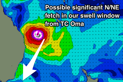
 The longer term outlook is much more interesting as we turn our eyes north to Tropical Cyclone Oma.
Oma is currently just west of Vanuatu but forecast to track south-west while deepening significantly towards the SE Qld coast.
As it moves further south, a strong high pressure ridge to its south will see a fetch of severe-gale to storm-force N/NE winds being generated on its eastern flank, just within our swell window.
This may generate a flukey and rare pulse of N/NE groundswell for later next week that may persist for a few days depending on the movements of Oma.
The models are struggling to forecast where Oma will track and move at this early stage so check back here Monday for the latest update. Have a great weekend!

