Small N/NE windswells
Eastern Tasmania Surf Forecast by Craig Brokensha (issued Monday 14th January)
Best Days: Tuesday and early Wednesday
Recap
A small bump in the swell out of the north-east on Saturday, with a poor S'ly windswell yesterday in the wake of a change. Today the coast is tiny but some new north-east windswell should be on the build this afternoon and evening.
Today’s Forecaster Notes are brought to you by Rip Curl
This weekend and next week (Jan 15 - 20)
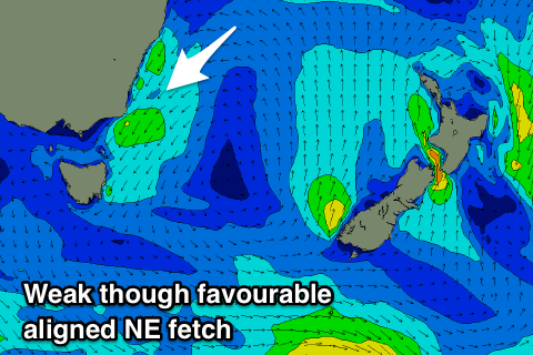
We've got a slight upgrade in the outlook for this week, with an extended run of small N/NE windswell due from tomorrow.
A strong high will sit in the Tasman Sea as weak surface troughs push in from the west, squeezing its western flank but not pushing it away.
 The strongest and best aimed fetch of N/NE winds are due to develop this afternoon and evening, producing 2-3ft of N/NE windswell tomorrow but with N/NE winds, stronger into the afternoon. Even though it'd be worth making the most of the size.
We'll see one of the troughs slip through overnight Tuesday bringing a S-S/SE wind early Wednesday, swinging E through the day.
This will favour those north-east swell magnets early but we'll be looking at a drop in size to 2ft+.
N/NE winds will persist off southern NSW but not extend down to us through the end of the week and as a result we'll see the N/NE windswell energy continuing to fade from 1ft to maybe 2ft Thursday and Friday, tiny into the weekend.
A light N'ly breeze is due Thursday while a better NW offshore should be seen Friday morning ahead of sea breezes.
Longer term there's nothing significant on the cards, so try and make the most of tomorrow (even though bumpy) and early Wednesday.

