Fun southerly groundswell, with a fleeting swell for the weekend
Eastern Tasmania Surf Forecast by Craig Brokensha (issued Monday 7th January)
Best Days: Tuesday south swell magnets, Saturday once the change hits
Recap
Building north-east swell on Saturday only small in the morning and biggest into the afternoon with great conditions. Sunday was clean again but small and easing, tiny today.
Today’s Forecaster Notes are brought to you by Rip Curl
This week and weekend (Jan 8 - 13)
A late increase in S'ly groundswell may bee seen today, but tomorrow is the best chance to surf it.
This was generated by a strong polar low moving through our swell window over the weekend, with it now pushing off to the east under New Zealand.
 A peak in size is expected tomorrow morning to 3ft across south magnets, if not bigger, easing through the day and then tiny to flat on Wednesday.
Conditions will be great for south magnets tomorrow with a NW offshore persisting most of the day.
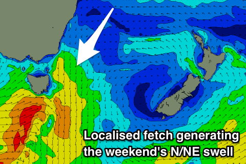
Our next increase in swell looks to arrive out of the N/NE, with a strong but short-lived fetch of N/NE winds forming in our northern swell window Friday afternoon and evening.
The fetch is due to hold until early Saturday morning before a trough moves in from the west, bringing a S/SW change.
This will make for a dynamic but good period of surf with the N/NE windswell peaking around the 3ft range if not a little more as that change moves through.
The change will whip up a weak messy S'ly windswell for Sunday with gusty S'ly winds.
Our possible NE groundswell from a tropical low below Fiji has been downgraded with the low being weaker and not retro-grading as far south-west as was forecast last Friday.
Instead we'll probably see small levels of S'ly groundswell through next week, but more on this Wednesday.

