Small N/NE swell tomorrow, with a S'ly swell early next week
Eastern Tasmania Surf Forecast by Craig Brokensha (issued Friday 4th January)
Best Days: Saturday morning, Tuesday south magnets
Recap
A small bump in southerly swell yesterday but with average winds, clean this morning with a background E swell to 1-2ft.
Today’s Forecaster Notes are brought to you by Rip Curl
This weekend and next week (Jan 5 - 11)
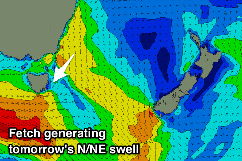
A strengthening and broadening fetch of N/NE winds are now building in our north-eastern swell window, and we're still expected to see this fetch reach maturity this evening before a strong mid-latitude low pushes in from the west and moves the fetch out of our swell window early tomorrow morning.
As a result a peak in size is expected tomorrow morning with 2-3ft sets across north-east swell magnets, easing into the afternoon and tiny Sunday.
 Winds tomorrow are looking good though not ideal for north-east magnets with a W/NW offshore ahead of NE sea breezes.
We've got an upgrade in the surf potential for Tuesday with a strong polar low due to produce a fun S'ly groundswell.
A fetch of polar severe-gale to storm-force W/SW winds will move more into our swell window over the weekend before moving on further under New Zealand early next week.
The swell should arrive overnight Monday and peak Tuesday to a good 3ft across south swell magnets. Conditions look favourable with a N/NW-N breeze, with the swell easing into the afternoon, tiny Wednesday.
The rest of the outlook remains quiet, with a possible small NE groundswell showing late next week and into the weekend, generated by a tropical low retro-grading from below Fiji early next week. We'll have a closer look at this Monday. Have a great weekend!

