Small pulse of N/NE windswell over the weekend
Eastern Tasmania Surf Forecast by Craig Brokensha (issued Friday 28th December)
Best Days: Late Saturday and Sunday morning at north-east magnets
Recap
No surf the last couple of days with tiny amounts of background NE swell.
Today’s Forecaster Notes are brought to you by Rip Curl
This weekend and next week (Dec 29 – Jan 3)
The one question we all want to know, is there going to be a surfable wave on the weekend?
Well in short yes, Saturday is looking dicey and mostly tiny until late, with Sunday morning revealing the best chance for a wave.
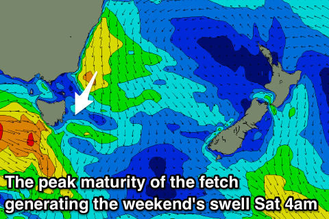
A persistent strong fetch of NE winds off the southern NSW coast isn't extending down to us or even across Bass Strait until just before dawn tomorrow morning.
 At dawn a projection of the fetch should produce a small increase in N/NE windswell Saturday afternoon likely to 2ft at north-east facing beaches, tiny most of the day ahead of it.
The fetch will remain positioned in our swell window through tomorrow morning, retreating into the afternoon, but the swell from this sustained fetch of winds should hold Sunday morning.
Size wise I wouldn't expected anything over 2ft and the models are incorrectly combining a small mid-period trade-swell signal with the localised swell and over-forecasting the size.
The swell will ease through the day, and Monday then looks tiny again and back to 1-1.5ft if that.
Winds on Saturday will be offshore out of the NW, tending variable ahead of a late SE change.
Sunday looks good across those north-east magnets with an early S/SW breeze, tending E/SE and then E/NE into the afternoon.
Monday looks average with N/NW tending fresher N/NE winds ahead of a W/NW change Tuesday.
Longer term we may see some small S'ly groundswell spreading into our south magnets on Thursday from a strong and broad polar frontal progression moving under the state, with some small N/NE windswell late week, but more on this Monday. Have a great weekend!

