Large NE swell developing, excellent Monday
Eastern Tasmania Surf Forecast by Craig Brokensha (issued Friday 14th December)
Best Days: Sunday northern corners, especially later, Monday, Tuesday morning
Recap
Building levels of NE windswell through yesterday, up bigger this morning and with favourable winds for spots seeing all the size. The low hasn't reached the strength it was forecast to, hence the size coming in at 3-4ft, but we've got larger surf to come.
Today’s Forecaster Notes are brought to you by Rip Curl
This weekend and next week (Dec 15 - 21)
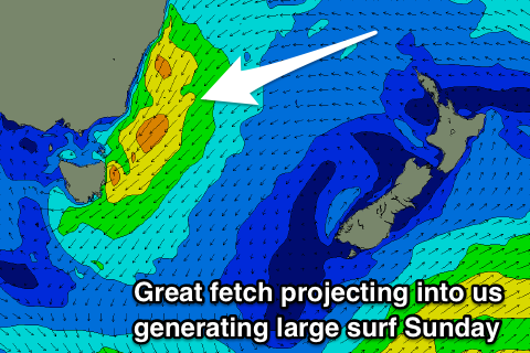
Currently a broad and intense mid-latitude low is sitting across the south-east corner of the country, and we'll see this lows centre slowly move south-southeast, squeezing a strong high in the Tasman Sea.
This will result in the current fetch of strong E/NE-NE winds being generated in our swell window to swing more NE and extend from Newcastle down to us while strengthening.
 With this we'll see the NE windswell event muscling up through tomorrow, more so into the late afternoon and evening and becoming large into Sunday.
Tomorrow morning looks to come in around 4ft, building later in the day towards 6ft on the sets, but Sunday will see all the size with strong consistent 8ft sets developing through the morning.
Winds are looking poor tomorrow and strong from the E/SE, tending E/NE into the afternoon, while Sunday will start poor with a strong NE'ly, tending lighter N/NW by mid-afternoon and then NW late in the day.
Monday looks to now see great W/NW offshore winds, giving into weak sea breezes, as a S'ly change looks delayed until late in the day.
Size wise, there should still be solid easing sets from the 5-6ft range owing to a strong fetch of NE winds remaining in our swell window through Sunday evening.
Tuesday will be smaller and easing from 3ft, with an early S/SW breeze, tending SE through the day and with no real windswell in the wake of the change.
Longer term we may see a small spike in windswell from the NE again next week, but not to the size or power of our current event.

