Very dynamic period ahead
Eastern Tasmania Surf Forecast by Craig Brokensha (issued Monday 19th November)
Best Days: Wednesday, Thursday in protected spots, Saturday protected spots, Sunday
Recap
A small mix of E/NE and E/SE swells to 1-2ft or so on the weekend, ahead of our better E/NE trade-swell today to 2-3ft but with a freshening NE'ly.
Today’s Forecaster Notes are brought to you by Rip Curl
This week and weekend (Nov 20 - 25)
We've got a very active period ahead with a good increase in N/NE windswell ahead of a large windy SE swell.
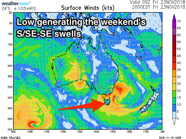
Currently an approaching trough across the country is forecast to develop into a deepening mid-latitude low, squeezing a high in the Tasman Sea and generating a strengthening fetch of NE winds down our coast.
We'll see this fetch linger and strengthen more than forecast last week and with this we're due to see a bigger increase in NE windswell energy.
 North-east facing beaches should build to 3ft+ later tomorrow, with larger 4ft surf on Wednesday morning as a NW tending S/SW change pushes through.
This should create excellent waves across northern corners as the swell eases.
Also in the mix on Thursday should be 3-4ft of E/SE swell, generated by a great prolonged fetch of strong E/SE winds off the southern tip of New Zealand today and tomorrow. Winds will become strong from the S'th though as the mid-latitude low move across us and strengthens right off our coast. A fetch of strong to gale-force S-S/SE winds are forecast to be projected up through our southern swell window.
The models are still moving around regarding the positioning and strength of the low but we're likely to see large windy surf building Friday and peaking Sunday around 5-6ft or so with S/SW winds.
The swell will ease quickly as the low weakens on the weekend, but check back here Wednesday for more on this.

