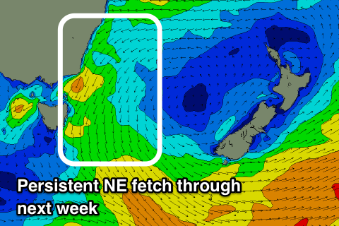
Easing S'ly swell energy and building NE swell energy
Eastern Tasmania Surf Forecast by Craig Brokensha (issued Friday 12th October)
Best Days: South swell magnets Saturday morning, northern corners Monday through Wednesday, Thursday morning, Friday
Recap
A good fun easing S/SE swell yesterday with morning offshores, smaller and back to 2ft this morning. A new S'ly groundswell should be showing across south magnets this afternoon with winds swinging favourably to the NE.
Today’s Forecaster Notes are brought to you by Rip Curl
This weekend and next week (Oct 13 – 19)
This afternoon's late kick in S'ly groundswell should peak overnight, but ease back from a good 3ft to possibly 4ft at south swell magnets at dawn tomorrow, smaller into the afternoon with a N/NW tending fresh NE breeze.
A small new S'ly groundswell should also be in the mix to 2ft on Sunday, generated by a polar front that's developed in our swell window today.
We then look at our prolonged NE swell event from Sunday through most of next week, owing to a strong and slow moving high in the Tasman Sea, squeezed by a slow moving mid-latitude low forming in the Bight and pushing east most of next week.
 This will project a persistent fetch of strong and broad NE winds through our swell window from Sunday through Thursday, but strongest Monday and Tuesday when the mid-latitude low is strongest.
We'll see building levels of NE windswell through Sunday, becoming stronger mid-period energy on Monday with sets pushing towards 4-5ft at north-east facing beaches, with a peak likely Tuesday morning to 4-6ft.
The fetch will only slowly weaken through the end of the week, and as a result so will the swell ahead of a NW change on Friday.
Winds through this period will generally be onshore and out of the N/NE, possibly more N'ly early Tuesday and W/NW Thursday morning if we're lucky. Check back here on Monday though for the timing of the peak in swell and local winds.
Have a great weekend!

