Very active period ahead
Eastern Tasmania Surf Forecast by Craig Brokensha (issued Wednesday 22nd August)
Best Days: Thursday and Friday mornings, Saturday, southern corners later Monday, Wednesday
Recap
A fun clean pulse of SE groundswell yesterday with good winds through the morning, while a southerly change has brought some new S'th swell this morning which eased rapidly, mixed in with leftover SE swell.
This week and weekend (Aug 23 - 26)
Today’s Forecaster Notes are brought to you by Rip Curl
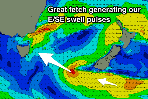
 Our good pulses of E/SE swell due over the coming days is still on track, with a great elongated fetch of strong E/SE-SE winds being generated and projected through our eastern swell window from yesterday afternoon.
We should see an initial strong pulse of E/SE swell tomorrow, arriving by mid-morning and reaching 3-4ft across open beaches with a morning NW offshore, swinging onshore through the day as a little trough develops off the coast.
Reinforcing and slightly less consistent amounts of E/SE swell from under New Zealand will arrive through Friday keeping 3ft to occasionally 4ft waves hitting open beaches with a W/NW tending E'ly breeze.
Into the weekend the swell will start easing but from a fun 3ft at dawn with a persistent W/NW offshore breeze.
A low point in swell is expected on Sunday ahead of a mix of NE and SE swells through early next week.
A strengthening surface trough off the East Coast mentioned in Monday's notes looks to move a little quicker than forecast but also form into a Tasman Low east of us through Monday/Tuesday.
We'll see an infeed of strong NE winds generating a small fun pulse of NE swell to 2ft to maybe 3ft by dark on Monday, fading Tuesday as a rapid increase in S/SE windswell is seen from the western flank of the low.
The surf is looking best on the backside of the event, but more on this Friday.

