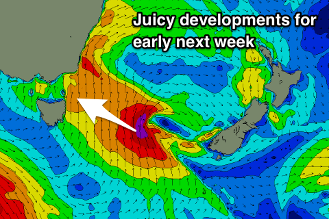
Much more active and exciting period ahead
Eastern Tasmania Surf Forecast by Craig Brokensha (issued Wednesday 15th August)
Best Days: Friday south swell magnets, Monday, Tuesday, Wednesday morning
Recap
Tiny to flat surf yesterday and today, but we've got some good swell due through the period.
This week and next (Aug 16 - 24)
Today’s Forecaster Notes are brought to you by Rip Curl
The surf will remain flat tomorrow, but our new pulse of S'ly swell for Friday is still on the cards, with a strong storm that's currently moving across the state generating a fetch of strong to gale-force S/SW winds in our southern swell window this afternoon through tomorrow morning.
We should see a fun pulse of S'ly swell arriving overnight Thursday and peaking Friday morning to 2-3ft across south swell magnets under offshore W/NW tending NW winds.
The swell is due to fade later in the day, dropping from a small to tiny 1-1.5ft or so Saturday morning as offshore winds persist from the W/NW.
 Moving onto Sunday, and a strong cold-outbreak mentioned on Monday looks to now take the form of a cut-off low, with the system moving across us through Sunday and developing into a strong Tasman Low into the evening.
We'll see a fetch of strong S/SE winds projected up our coast through Sunday kicking up a late increase in S/SE windswell though with poor conditions under strong S'ly winds.
As the low forms and stalls, a better fetch of gale-force S/SE winds will be generated to our south-east, just in our swell window, producing a better SE groundswell that's due to kick later Monday though peak Tuesday morning.
On Monday we'll see the S/SE swell easing from 4-6ft range, but likely not too much as the SE swell starts to fill in. Winds will be better and from the W/SW tending W. Tuesday looks excellent with a clean easing SE groundswell from 4-6ft.
The rest of the week looks smaller with nothing of significance until the following weekend, but check back here Friday for a better idea on the SE swell due early next week.

