She'll be coming round the corner
Eastern Tasmania Surf Forecast by Craig Brokensha (issued Monday 13th August)
Best Days: Friday and Saturday morning south swell magnets, Sunday protected spots, Monday south swell magnets
Recap
Fun levels of N/NE windswell on Saturday in the 3ft range, easing back through Sunday with cleaner conditions, tiny today.
This weekend and next week (Aug 14 - 19)
Today’s Forecaster Notes are brought to you by Rip Curl
Looking at the coming week, and as touched on last update, there's nothing significant at all, with the spike in swell shown on the models Wednesday being from the NW, and we won't see any surf at all.
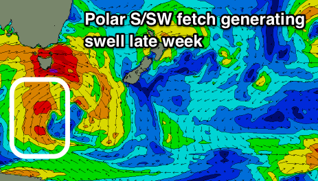
Late week though we should see a fun pulse of S/SW swell generated by a polar fetch of strong to gale-force S/SW winds to our south, on the backside of a vigorous mid-latitude low pushing across us.
 This swell might be seen late Thursday but is expected to peak on Friday with 2-3ft sets across south magnets under a favourable offshore W/NW breeze.
Saturday looks small to tiny as the S'ly swell drops, with 1-2ft leftovers on the coast.
We then look ahead to a strong cold-outbreak forecast across the state later in the weekend, with a strengthening polar front due to project up and past us.
While not especially strong we should see a broad fetch of strong to near gale-force S/SW winds produced past us Saturday evening, weakening through Sunday.
At this stage we're probably looking at 3-5ft of S'ly swell with SW tending S/SW winds on Sunday, easing Monday with better W/NW offshores. We'll have a closer look at this on Wednesday as the models are shifting around slightly regarding the strength of this front.

