Large southerly storm swell late Sunday and Monday
Eastern Tasmania Surf Forecast by Ben Matson (issued Saturday 16th June)
Best Days: Sun/Mon: protected spots. Tues: fun clean beaches. Wed/Thurs/Fri: only small, but clean with NW winds.
Recap: A continuation of tiny waves across the East Coast, best for beginners.
Today’s Forecaster Notes are brought to you by Rip Curl
This week and weekend (Jun 14 - 17)
Want to receive an email when these Forecaster Notes are updated? Then log in here and update your preferences.
Note: Today’s Forecaster Notes will be brief, as Craig is away on annual leave. Also, these Forecaster Notes will be updated Tuesdays, Thursdays and Saturdays for the next few weeks.
The synoptic chart looks very impressive with a deep low immediately to our south, and Cape Sorell buoy showing a lot of energy - however the main fetch around the western flank of the low is outside our swell window, aimed up into SA and western Vic.
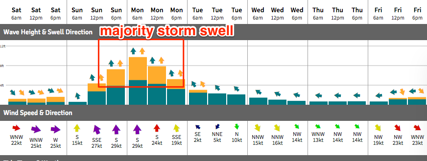
As such, we’ll continue to see tiny to flat conditions through Saturday, and early Sunday - the low is expected to move properly into our swell window on Sunday morning, but it doesn’t look like it’ll gather strength until the middle of the day - so we won’t see a notable upswing in size until the afternoon. In any case it’ll be accompanied by gale force southerlies.
Monday will see a peak in short range southerly storm swell, with strong to gale force winds accompanying form the same direction. Both late Sunday and Monday will only have surfable options at extremely sheltered locations.

As the low then exits north-east into the Tasman Sea, we’ll see a steady drop in size from Tuesday onwards - though a high pressure system moving in from the east will quickly steer winds around to a light northerly, so we’ll see a rapid improvement in quality. Size will probably be down to about 3-4ft at exposed beaches by this time (smaller into the afternoon as it continues to ease).
Small residual swells are then expected for the long term. A moderate SE fetch through the Central Tasman Sea mid next week will be positioned outside of our swell window but we may see a small spread of energy back into our coast. Otherwise, the storm track looks unfavourable for any notable size beyond the middle of next week at this stage. More on this in Tuesday’s update.

