Small lingering south swell, with a fun S/SE groundswell Tuesday
Eastern Tasmania Surf Forecast by Craig Brokensha (issued Friday 20th April)
Best Days: South magnets over the coming days, Tuesday
Recap
Good fun easing levels of S'ly groundswell yesterday from 2-3ft with favourable winds in the morning.
Today we're back to small to tiny surf.
Today’s Forecaster Notes are brought to you by Rip Curl
This week and weekend (Apr 21 - 27)
There's nothing too major on the cards for the weekend, but a persistent weak fetch of SW winds along the polar shelf should keep infrequent 1-2ft sets hitting south magnets tomorrow and Sunday.
A light variable wind should create clean conditions tomorrow morning ahead of N/NE sea breezes and then W/NW tending N/NE winds Sunday.
 Monday morning may see 1-2ft sets lingering but into the afternoon and more so Tuesday our new S/SE groundswell is expected.
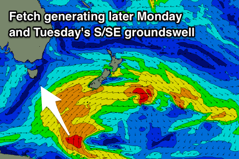
On top of the weak fetch of polar SW winds linked to the weekend's swell we'll see a good fetch of S'ly gales projected north through our swell window tomorrow, south of New Zealand.
A fun S/SE groundswell is expected to arrive later Monday and build to 2ft, with a peak Tuesday morning around 3ft with improving N/NE tending N/NW winds.
The swell should ease through the afternoon and down further from 2ft Wednesday morning under a W/NW'ly.
Longer term the models have been toying with a deepening low in the Tasman Sea which could bring us some good swell potential, but we'll have to review this Monday. Have a great weekend!

