Fun waves Saturday morning, dynamic next week
Eastern Tasmania Surf Forecast by Craig Brokensha (issued Friday 12th January)
Best Days: Saturday morning, Tuesday morning protected spots, Wednesday afternoon and Thursday
Recap
Early light winds and a good pulse of E/SE swell to 2-3ft with building levels of N/NE windswell later in the day.
Today the N/NE windswell has jumped further with a good fetch off the coast producing 3-4ft of NE swell, cleanest in northern corners.
The swell is expected to climb a touch further as winds persist from the north.
Today’s Forecaster Notes are brought to you by Rip Curl
This week and weekend (Jan 13 - 19)
The fetch generating today's building NE windswell will weaken off our coast locally this evening, but one final strong burst of N/NE gales just east of Bass Strait should keep fun sets hitting the coast early tomorrow morning.
North-east facing beaches are expected to be around 3ft, mixed in with 2-3ft of E/SE swell from the fetch of SE winds off the tip of New Zealand's South Island.
Both swells will ease steadily through the day and a morning SW-S/SW wind will create clean conditions, onshore into the afternoon.
 Sunday morning looks small to tiny with a just a weak new S'ly windswell from a weak front pushing up past us.
Into the afternoon our small pulse of S'ly groundswell is still on the cards, generated by a tight intense low forming south-southwest of the state this evening.
Only 2ft sets are due across south magnets into the afternoon and a morning W'ly breeze is due to give into afternoon sea breezes.
Into next week we've got a couple of tricky swell sources.
Firstly Monday morning will start tiny, but a polar front pushing up past us is likely to produce a small spike in S'ly windswell later in the day though with poor winds. The swell should hold into Tuesday morning to 3ft+ across south facing beaches but with a S/SW tending S/SE breeze.
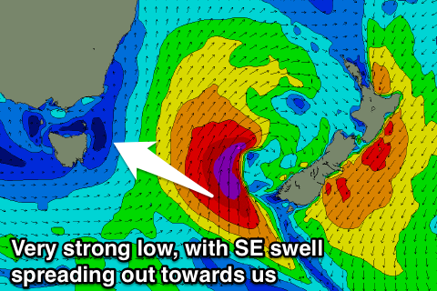
This front is then due to form into a deep Tasman Low on Tuesday with a very intense fetch of severe-gale to storm-force S/SW winds due to be generated just outside our swell window.
Due to the strength of the low though, we should see some small SE groundswell spreading out radially into the northern half of the coast, building Wednesday and peaking Thursday morning.
At this stage we're looking at a kick to 2-3ft Wednesday afternoon, with a peak Thursday to 3-4ft. Though with such a dynamic system, we'll have to review this Monday. Have a great weekend!

