Easing E/SE swell, with a fun N/NE windswell Thursday morning
Eastern Tasmania Surf Forecast by Craig Brokensha (issued Friday 6th October)
Best Days: Tuesday morning, Thursday morning, Saturday afternoon south magnets
Recap
Average Saturday with a small easing S/SE swell with light onshore winds, while Sunday morning saw small peaky waves out of the E/NE with an early offshore.
Later in the day and more so today though a good E/SE groundswell has come in, offering pumping 3-4ft waves across open beaches. We should of seen the swell start to ease this afternoon under a persistent offshore wind.
This week and weekend (Oct 10 - 15)
The deep Tasman Low responsible for this morning's E/SE groundswell has since weakened and with this we'll see the swell easing further through tomorrow, back from 2ft to possibly 3ft across open beaches, much smaller into the afternoon.
Conditions will be great through the morning with a W/NW offshore before weak sea breezes kick in.
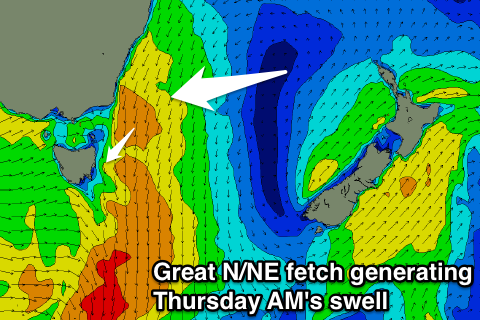
 Wednesday morning will start clean but tiny, though we'll see some good N/NE windswell building later in the day and peaking Thursday morning.
We'll see a great fetch of elongated and broad N/NE winds forming down the southern NSW coast and extending to us on Wednesday afternoon and evening, pushing away from us early Thursday.
We should see a messy and late increase in size to 3ft Wednesday, with the swell dropping rapidly from a similar 3ft at dawn Thursday, back to 1-2ft through the day under fresh W/NW winds.
There'll be no major swell to follow this change, with some real small refracted S'ly groundswell possible Saturday afternoon to 2ft+ at south magnets with offshore winds.
Longer term we're looking at persistent N/NE fetches forming in our swell window generating fun amounts of windswell but more on this Wednesday.

