Easing S/SE swell tomorrow with a good E/SE swell Monday
Eastern Tasmania Surf Forecast by Craig Brokensha (issued Friday 6th October)
Best Days: Saturday morning south magnets, Monday, Tuesday morning
Recap
A small building NE windswell through yesterday, biggest into the afternoon as winds tended offshore near dark.
Today a deepening surface trough moving offshore has brought with it a building S'ly windswell but poor winds.
This weekend and next week (Oct 7 - 13)
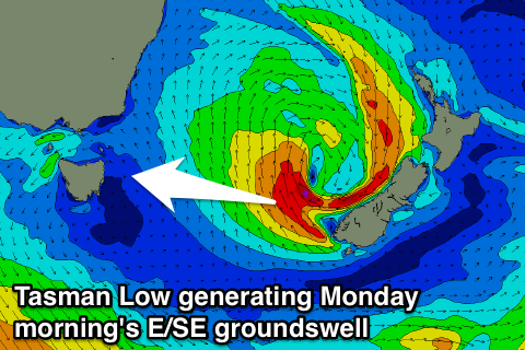
The surface trough linked to today's building S'ly windswell will move off to the east-northeast this afternoon while forming into a broader Tasman Low towards New Zealand.
With this the fetch of S'ly winds will weaken and move away from our coast overnight resulting in a rapid drop in S/SE from 2-3ft at magnets tomorrow morning.
Conditions should be clean with a light morning offshore before E/NE breezes kick in.
 Looking at our E/SE groundswell and the Tasman Low is expected to take a little longer to deepen and will form further away towards New Zealand tomorrow, and with this the timing of the swell has changed, with a peak now due Monday morning.
We may see a late pulse Sunday but instead we're likely just to see a small mix of E/SE and building NE windswell to 2ft+ into the afternoon, smaller early. Strengthening N/NE winds will also create poor conditions.
Come Monday though conditions look great with a peak of E/SE groundswell to 3ft+ or so early with W/NW winds.
The swell will then fade into the afternoon, back from 2ft Tuesday.
Beyond this there's nothing major on the cards besides another small N/NE windswell late Wednesday/Thursday, but more on this Monday. Have a great weekend!

