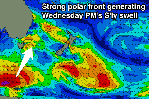
Good clean S'ly groundswell for Wednesday afternoon
Eastern Tasmania Surf Forecast by Craig Brokensha (issued Monday 25th September)
Best Days: Fun S'ly swell Wednesday afternoon, fading Thursday with a small N/NE windswell, possible swell Sunday
Recap
Tiny to flat surf all weekend, with a spindrift of east swell this morning, but still tiny.
This week and weekend (Sep 26 – Oct 1)
A small pulse of S'ly swell expected off a low passing across us today looks very limited.
No major fetch length or strength will be aimed in our swell window, with 1-1.5ft surf max due early, fading through the day.
 A better S'ly groundswell is likely Wednesday afternoon though, generated by a strong polar frontal system that's currently south of the state.
A great fetch of severe-gale to storm-force W/SW winds are being generated, with a good increase in size due to 2-3ft at south facing beaches into the afternoon moderate N/NW tending fresh N/NE breeze, back to the N/NW later. Therefore south facing beaches should be great all day.
A small pulse of NNE windswell is expected off the strengthening N/NE fetch down the NSW coast late in the day Wednesday but a peak is likely after dark to 2-3ft, fading into Thursday from 2ft+. The southerly groundswell will likely be easing from a similar size and W/NW tending W/SW winds will create great conditions.
Into the end of the week we'll see a series of vigorous storms pushing across us but they all look too zonal to generate any S'ly swell for us.
The best aligned system may generate some small S'ly swell for Sunday morning with W/NW winds, but we'll have a closer look at this Wednesday.

