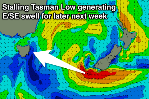
Fun Saturday, much better swell later next week
Eastern Tasmania Surf Forecast by Craig Brokensha (issued Friday 4th August)
Best Days: Saturday morning, Wednesday morning, Thursday onwards
Recap
Great waves yesterday morning with a good E/SE swell in the 3-4ft range with a morning offshore. Onshore winds developed through the day, persisting into today creating sloppy conditions as the E'ly swell eased back a notch.
This weekend and next week (Aug 5 - 11)
While today's swell is dropping away, a new pulse of E'ly swell is due overnight and into tomorrow, generated by a fetch of E'ly gales exiting Cook Strait (gap between New Zealand's North and South Islands) yesterday.
This should provide 2-3ft sets tomorrow morning, easing off slowly through the day, back down from 1-1.5ft Sunday.
 Conditions will be great tomorrow with NW offshores, stiffer into Sunday.
One final intensification of strong but poorly aligned E/NE winds off NZ's South Island's West Coast should produce a small final pulse of E'ly swell Monday to 1-2ft.
Conditions look clean early with a W/SW offshore, giving into a S'ly change into the afternoon.
This change will be linked to a mid-latitude moving east across us and a good fetch of strong S/SE winds will be projected through our south-eastern swell window.
Another broad and intense Tasman Low is forecast to form and stall over New Zealand, aiming a persistent fetch of gale-force E/SE winds towards us.
What we should see is a fun pulse of S/SE swell for Tuesday to 3ft+, easing from 3ft Wednesday morning ahead of E/SE groundswell from Thursday afternoon through next weekend. Winds are looking NW as well, but we'll dial down the specifics on Monday. Have a great weekend1

