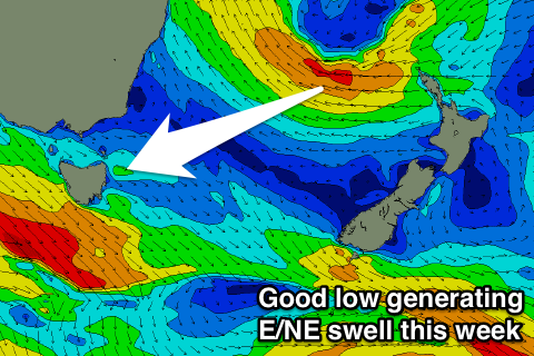
Great E/NE swell Thursday mixed in with S swell
Eastern Tasmania Surf Forecast by Craig Brokensha (issued Monday 19th June)
Best Days: Wednesday, Thursday, Friday, Saturday and Sunday south swell magnets
Recap
Small clean and easing surf from 2ft at magnets Saturday, tiny Sunday.
A small spike of S'ly swell should have been seen later yesterday, with it easing back from 1-1.5ft this morning.
This week and weekend (June 20 - 25)
This morning's small hint of S'ly swell is due to be gone tomorrow, and we look ahead to the E/NE swell due later this week.
Currently a broad and strong Tasman Low is sitting east of Seal Rocks, generating a great fetch of strong to gale-force SE-E/SE winds.
The low is forecast to drift slowly south-east while broadening this evening, moving into our swell window.
We'll see a fetch of strong to gale-force E/SE winds aimed through our eastern swell window tomorrow as the low stalls between New Zealand and Australia, with a slight retro-grade towards us tomorrow afternoon helping to generate a good E/NE groundswell.
 The low will weaken into Wednesday but continue to aim a dissected fetch of strong E/NE winds towards us, resulting in a slow easing trend on the backside of the swell.
A tiny hint of NE swell is showing on the charts for late tomorrow, but I'm not expecting any real size until Wednesday when we should see open beaches building from 2ft during the morning to 3ft into the afternoon with a peak in size Thursday to 3-4ft or so.
We should then see the swell slowly easing from the 3ft range Friday morning smaller Saturday.
Winds Wednesday will swing from the W/SW to S'th with a strong cold front. This front will also likely generate some S'ly groundswell Thursday morning to 3ft at south magnets. Conditions will be great with an early W/NW breeze, tending N/NW mid-morning and then back to the NW into the afternoon, with strengthening W/NW tending W'ly winds Friday.
This strengthening W'ly will be related to a very strong cold-outbreak moving across us, with a fetch of storm-force SW winds forecast to be projected up from below the state, through our southern swell window.
A large and powerful SW groundswell will be generated for the South Arm Saturday, with us also seeing solid sets out of the south, coming in at 3-4ft across magnets. Winds look offshore and from the W, but we'll have a closer look at this Wednesday.

