Great waves from Sunday with a mix of swells
Eastern Tasmania Surf Forecast by Craig Brokensha (issued Friday 19th May)
Best Days: Sunday, Monday, Tuesday morning
Recap
A further drop in E'ly swell yesterday, back from 2-3ft across open beaches. This morning a new S'ly groundswell is being spoilt by onshore E'ly winds.
This weekend and next week (May 20 - 26)
Today's freshening E'ly winds are linked to a deepening low moving in from the west, squeezing a strong high in the Tasman Sea.
 We'll see this low continue pushing east over the coming 24 hours, resulting in winds strengthening and broadening through our swell window.
A fetch of strong to near gale-force E/NE winds will kick up a moderate sized increase in NE swell through tomorrow, with messy 4-5ft waves developing into the afternoon, larger on dark.
The low will push south-east overnight and with this we'll see the swell easing Sunday out of the E/NE from 3-4ft during the morning, back to 2-3ft later in the day.
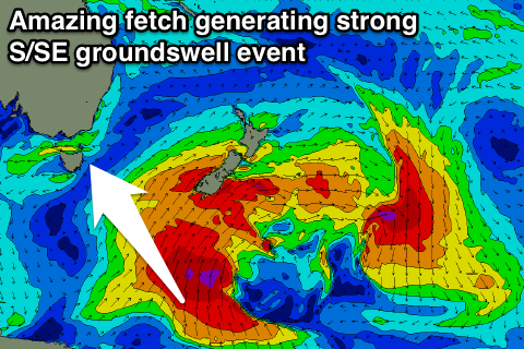
As this E/NE swell eases though, a strong new S/SE groundswell will take its place, with it already starting to be generated south of New Zealand.
 A vigorous polar low is projecting a fetch of gale to severe-gale S'ly winds up through our south-eastern swell window, resulting in a strong long-period S/SE groundswell for Sunday and Monday.
South facing beaches should build to at least 3-4ft by dark Sunday, with 4-5ft waves Monday morning, easing back into the afternoon, down from 2-3ft Tuesday.
Winds on Sunday will be great with the low dipping south-east, resulting in W/NW offshores, holding from the NW Monday and Tuesday.
Longer term we're expected to see small and inconsistent amounts of E/NE trade-swell from the Coral Sea, but with no major size expected. More on this Monday. Have a great weekend!

