Great forecast period with swells from all directions
Eastern Tasmania Surf Forecast by Craig Brokensha (issued Wednesday 17th May)
Best Days: Thursday morning, Friday keen surfers in protected northern corners, Sunday, Monday, Tuesday morning
Recap
A slow start to yesterday with small levels of SE swell, but this muscled up into the afternoon along with a late increase in E/NE groundswell.
This groundswell has peaked this morning with pumping 3-5ft waves across the East Coast under offshore winds. The swell should be easing across the coast this afternoon, but we've got plenty more energy to come.
This week and next (May 18 - 26)
The infeed of E/NE winds wrapping around the intense Tasman Low to our east (generating this morning's E/NE groundswell) moved out of our swell window yesterday, and with this we'll see the swell dropping this afternoon, down further from 2-3ft tomorrow morning. Conditions will clean through the morning ahead of a shallow S/SE change.
Into Friday our new S'ly groundswell is still on track, with a slight upgrade in size. A strong polar front is currently moving through our southern swell window, south of the state and we'll see this produce 3-4ft of S'ly groundswell for Friday morning at south facing beaches.
Unfortunately a deepening trough/low to our west will interfere with us earlier, with onshore E'ly winds due to freshen from the E/NE through the day. This will severely limit surfing options to select northern corners.
 This deepening trough/low will continue to strengthen through Saturday, with a good infeed of E/NE winds aimed through our swell window, slipping south Sunday.
The longevity of this fetch is short, but we should see onshore stormy waves building to 3-4ft on dark Saturday but with strong E/NE winds, peaking Sunday morning just as the low drifts south-east.
North-east facing beaches should see 4-5ft sets, but the size will ease steadily through the day with a NW change, with fading sets from 3ft Monday morning with W/NW tending NW winds.
One final swell will be in the water Sunday and Monday and this will be a strong long-period SE groundswell.
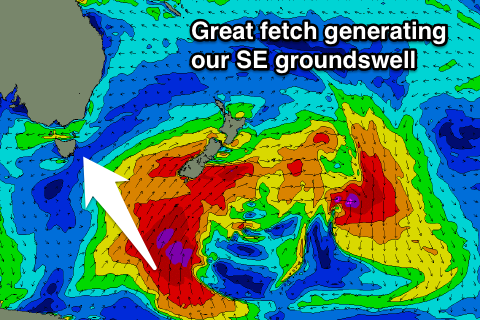
The front generating tomorrow's S'ly groundswell will be absorbed into a much more significant polar storm south of New Zealand.
We'll see a vast fetch of gale to severe-gale S'ly winds projected through our south-eastern swell window, producing a solid long-period SE groundswell, building Sunday afternoon to 3ft+ on dark, peaking Monday morning in the 4-5ft range.
This swell should then ease off slowly through Tuesday with nothing too major on the cards after this.
Therefore we've got a very dynamic period of waves ahead with lots of pumping days on the cards.

