Easing S/SE swell with a NE swell for the weekend
Eastern Tasmania Surf Forecast by Craig Brokensha (issued Monday 8th May)
Best Days: Tuesday protected spots, Wednesday south swell magnets, Saturday, Sunday morning
Recap
Saturday's flukey S/SE didn't really show on the East Coast, while Sunday started tiny, but we saw a rapid increase in swell through the afternoon although with average winds.
Today the swell was coming in at 3-5ft across open beaches, larger at south facing spots but with S/SW winds, limiting the cleanest waves to southern corners, which were much smaller.
This week and weekend (May 9 - 14)
The intense low pressure system responsible for our current S'ly swell peaked in intensity overnight/early this morning and with this we should of seen a peak in swell energy during today.
The low is now weakening while moving slowly east, with weaker S/SW winds blowing off our coast, through our southern swell window.
What we should see is easing levels of S'ly swell, with some S/SE energy in the mix, wrapping in from the bottom flank of the low.
South facing beaches should still see 3-5ft sets tomorrow morning, smaller into the afternoon and fading from 2-3ft out of the SE Wednesday morning.
Winds tomorrow will remain average for these south magnets with a morning SW breeze, tending S/SE through the day, while Wednesday is the pick with W/NW breezes all day.
Come Thursday we're looking at tiny clean leftover surf.
 Looking onwards from Friday, and our tiny NE trade-swell event has been upgraded slightly for our region.
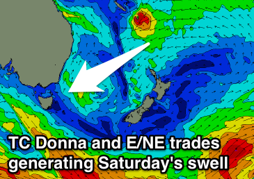
Currently Severe Tropical Cylcone Donna is drifting south-southeast between Vanuatu and New Caledonia, with a strong supporting high over New Zealand's North Island producing a stationary fetch of strong E/NE trades.
This fetch isn't really in our swell window, but as STC Donna drifts further south-southeast over the coming days, we'll see the fetch of E/NE trades dipping more NE and into our swell window.
We'll also see stronger core-winds around the weakening Donna produce some inconsistent NE groundswell for our coast as well.
We may see a late increase in NE trade-swell Friday afternoon, but the most size is due Saturday to an inconsistent 2-3ft across north-east swell magnets, easing back from 2ft Sunday morning.
Conditions are looking clean each morning ahead of afternoon sea breezes.
Longer term the outlook remains average, therefore make the most of the coming days surf.

