Small weekend NE swell, good E'ly swell Wednesday
Eastern Tasmania Surf Forecast by Craig Brokensha (issued Friday 21st April)
Best Days: Saturday north-east swell magnets, Wednesday, Thursday morning
Recap
A continuation of very inconsistent E/NE groundswell coming in at 1-2ft every 10-15 minutes, while today some tiny NE windswell was also in the mix.
This weekend and next week (Apr 22 - 28)
The NE windswell event seen today is actually looking a little better than on Wednesday.
We've got a healthy and persistent fetch of N/NE winds being aimed towards us, with it persisting into early tomorrow before pushing slowly east away from us, weakening tomorrow evening.
This should generate some fun NE windswell tomorrow morning to 2ft at north-east facing beaches, easing later in the day and then tiny Sunday.
 Conditions are looking nice tomorrow with a light NW breeze, tending W'ly ahead of a late change, and then S'ly tending S/SE winds Sunday.
Tiny surf is then expected Monday and Tuesday, while a cold front sweeping up and past us Wednesday isn't due to generate any decent size at all, with maybe a 2ft wave seen Thursday.
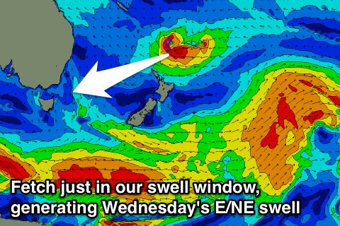
What will be in the water though is an inconsistent E/NE groundswell from a deepening low just on top of New Zealand's North Island.
This low is forecast to aim a fetch of gale to severe-gale E'ly winds, just within our swell window.
This should produce a small but strong E/NE groundswell for Wednesday, building to 2-3ft+ at open beaches through the day before easing from 2ft Thursday. Conditions will be clean with a SW breeze, and then W'ly winds Thursday.
We'll review the satellite passes over this low on Monday and confirm or adjust the size. Have a great weekend!

